#LiDAR
日本語で読みたい方は、 google chromeで開き、
画面上で右クリックをして、「日本語に翻訳」をクリックしてください
Aug 08, 2024

What is mobile LiDAR scanning and how does it work?
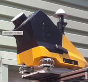
It is a data acquisition method that uses a continuously moving platform to collect survey-grade 3D point data quickly and accurately. It is more than just a laser scanner mounted on a moving platform: a single mobile scanning system integrates cameras, sensors, positioning and orientation system technology, and a control unit.
Data capture process, system components, and final outputs
The data capture process works as follows: while the platform moves, each laser scanner emits laser beams to capture road surfaces and objects above and alongside the road. The pulse travel enables calculating the distance between the sensor and the object. In addition to measuring ranges, the laser scanner also captures the scan angle and intensity of the return.
3D coordinates for each point are provided by the system’s Inertial Navigation Unit (INS), which combines an integrated GNSS antenna and an Inertial Measurement Unit (IMU). An IMU is a navigation device that continuously determines the velocity, and orientation of a moving platform. This data is required to position the scanning system and the data it captures. Specialized software can use that location data to store and visualize all points in a single 3D point cloud.
In addition to the scanners for detecting objects and surfaces, a mobile LiDAR scanning system contains cameras that help with asset visualization in relation to the scan data. As the vehicle goes along a set path, the scanners collect millions of data points that result in a highly-accurate and dense 3D point cloud of the surrounding area.