#LiDAR
日本語で読みたい方は、 google chromeで開き、
画面上で右クリックをして、「日本語に翻訳」をクリックしてください
See How One Surveying Firm Uses Aerial, Mobile, and Handheld LiDAR to Expand Their Business
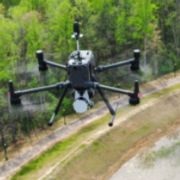
GeoCue announces the premiere of a new three-part edition of its award-winning drone surveying reality series, Down to Earth. The latest episodes feature BSI Engineering and Surveying and showcase how this Alabama-based firm has leveraged a full spectrum of LiDAR technology—aerial, mobile, and handheld—to drive efficiency, scale operations, and unlock new opportunities. See how in the first episode of Down to Earth, The LiDAR Triple and watch HERE.
この情報へのアクセスはメンバーに限定されています。ログインしてください。メンバー登録は下記リンクをクリックしてください。