3D laser scanning standards and specifications for Caltrans applications were developed to promote large-scale deployment of this technology into Caltrans day-to-day survey operations.
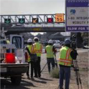
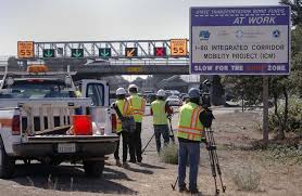
This report documents the AHMCT research project, “Creating Standards and Specifications for the Use of Laser Scanning in Caltrans Projects.” DOTs and private contractors have used laser scanning in highway survey applications and found that it reduces lane closures, decreases the risk of casualties, and can increase productivity over traditional survey instruments. The resulting high-resolution detailed 3D models, augmented by traditional survey measurements via Total Station and GPS, allow engineers to extract all the required data, decreasing or eliminating the need for surveyors to return to sites for additional measurements. To fully realize the benefits, 3D laser scanners must be used properly and in appropriate applications with full understanding of any limitations.
This report provides a detailed background and summary of previous work on tests and procedures to evaluate 3D laser scanner accuracy and other relevant technical specifications. AHMCT researchers created a set of vendor-neutral standard test protocols for the characterization and performance evaluation of 3D laser scanner performance, which users can conduct in easily accessible facilities in which to perform the evaluation. Test results of Time-of-Flight based 3D laser scanners are presented. Post-processing software is a crucial and integral part of the terrestrial LIDAR survey system. Besides providing visualization, it helps users to extract data and produce required deliverables, such as linear and volumetric measurements, geometric feature values, geo-referencing / registration error, topographic drawings, CAD models, TIN/DTM, etc. Furthermore, the post-processed data must support export to other Caltrans CAD software, e.g. CAiCE and MicroStation. Thus, the project also included point cloud post-processing software evaluation from major LIDAR vendors.
The standards and guidelines developed in this research and presented in this report will promote consistent and correct use of 3D laser scanners throughout Caltrans and by its contractors. The guidelines clarify the common limitations of 3D laser scanners and recommend mitigation methods; this will help engineers and surveyors to select the right scanner and determine optimum scanning settings for survey applications. These evaluations focused on issues that are of significant concern to Caltrans survey applications, workflows, and data flows. The report also provides a CAD data format for archival and exchange purposes, along with recommendations for terrestrial LIDAR-based workflows.
出典:https://lidarnews.com/articles/3d-laser-scanning-standards-caltrans/
この情報へのアクセスはメンバーに限定されています。ログインしてください。メンバー登録は下記リンクをクリックしてください。