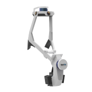
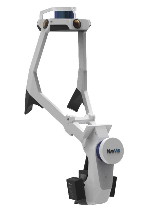
NavVis VLX is a first-of-its-kind wearable mapping system designed for hands-free, all-in-one reality capture, including survey-grade point clouds, in even the most complex environments such as construction sites, staircases and technical rooms
May 12th, 2020 – We are very proud to announce the launch of NavVis VLX, a first-of-its-kind wearable mapping system that captures high-quality data in even the most complex built environments. The unprecedented data quality delivered by a compact, versatile device sets a new industry standard and is a big step towards mainstream adoption of mobile mapping for surveying buildings.
The all-in-one reality capture capabilities of NavVis VLX include both survey-grade point clouds and high-resolution panoramas. NavVis VLX is equipped with two LiDAR sensors and is able to quickly and efficiently capture survey-grade point clouds using the same ground-breaking SLAM technology that NavVis has developed for its industry-leading system, NavVis M6. Along with point clouds, NavVis VLX captures high-resolution panorama images in a complete 360° field of view, which is a result of four strategically positioned cameras.
この情報へのアクセスはメンバーに限定されています。ログインしてください。メンバー登録は下記リンクをクリックしてください。