#LiDAR
日本語で読みたい方は、google chromeで開き、
画面上で右クリックをして、「日本語に翻訳」をクリックしてください
A Multi-Scale Case Study Featuring Interactive Reports Now Available on the ESRI Story Map

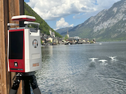
The RIEGL VZ-600i preparing to scan the historic landscape of Hallstatt, Austria
Please find here more information on the Hallstatt Case Study Project provided in English, followed by a German version. Click the following link to go straight to the ESRI Story Map: Case Study Hallstatt
RIEGL is proud to present a groundbreaking LiDAR case study in Hallstatt, Austria, a
UNESCO World Heritage Site recognized by the United Nations Educational, Scientific and Cultural Organization for its outstanding cultural and natural significance. Launched in 2025, the project highlights how RIEGL’s advanced 3D laser scanning technology delivers powerful insights across diverse environments and scales, revealing new dimensions of one of Europe’s most iconic landscapes.
The Hallstatt project was designed to push the limits of LiDAR technology. From steep, hard-to-reach valleys and retreating glaciers to ancient salt mines, archaeological sites, and evolving vegetation, the region presents a diverse array of features for observation. These conditions make Hallstatt an ideal testbed for demonstrating the flexibility and precision of RIEGL’s sensor portfolio.
“The world heritage site Hallstatt is a breathtaking place well-known for its long-term history.” said Bernhard Groiss, RIEGL Senior Technical Expert LiDAR Applications. “For the last 8000 years humans have been present mining for salt, facing the everyday challenges of living in a harsh alpine environment and transforming the landscape into a unique cultural heritage site it is nowadays. Recording this location in 3D with all different types of LiDAR sensors developed by RIEGL is first a great honor but also an amazing chance to highlight the capabilities and characteristics of the diverse portfolio of RIEGL´s sensors and their efficient surveying workflows”.
この情報へのアクセスはメンバーに限定されています。ログインしてください。メンバー登録は下記リンクをクリックしてください。