#LiDAR 森林情報取得調査において約8 割の業務工数削減が見込めることを確認 株式会社日立システムズ(代表取締役 取締役社長:柴原節男、本社:東京都品川区/以下、日立システムズ)は、宮城県牡鹿郡女川町
続きを読む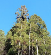
#LiDAR 森林情報取得調査において約8 割の業務工数削減が見込めることを確認 株式会社日立システムズ(代表取締役 取締役社長:柴原節男、本社:東京都品川区/以下、日立システムズ)は、宮城県牡鹿郡女川町
続きを読む
#LiDAR 高度なSLAM(Simultaneous Localization and Mapping)技術で世界をリードするKudan株式会社(本社:東京都渋谷区、代表取締役CEO:項 大雨、以下 Ku
続きを読む
本研究所 山本和久教授と藤寛特任教授ら研究グループの「レーザー光による害虫駆除技術を開発」―殺虫剤を使わずにレーザー光によって害虫を撃ち落とす新技術―が、2023年農業技術10大ニュースに選ばれました。 「農業技術10大
続きを読む
地理空間情報アプリプラットフォームサービス「mapry」を提供する株式会社マプリィ(本社:兵庫県丹波市、代表取締役:山口圭司、以下「マプリィ」)は、mapryドローン版(iOS)と連携し三次元点群データを取得することので
続きを読む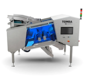
有毒なチョウセンアサガオやイヌホオズキといった雑草は、インゲン豆やベビーリーフ、ホウレンソウなどの作物と一緒に収穫されることが多く、最終製品に混入する危険性があります。しかし、トムラの画期的な選別技術により、このリスクを
続きを読む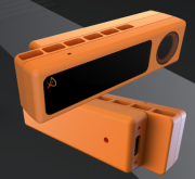
日本語で読みたい方は、 google chromeで開いて、 画面上で右クリックをして 「日本語に翻訳」をクリックしてください Portland, OR – August 1, 2023 – PreAct Technol
続きを読む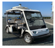
2023年9月6日 アイサンテクノロジー株式会社 アイサンテクノロジー株式会社(本社:愛知県名古屋市、代表取締役社長:加藤 淳)は、「幸田町におけるドローン・自動運転車連携による農産物・買い物支援輸送」をテーマとした実
続きを読む
Kudanモバイルマッピング開発キットのユーザーが、実際に様々な用途でキットを使った事例を今後紹介させて頂きます。本記事では、コーネル大学生態進化生物学部のBiosphere Modeling and Monitorin
続きを読む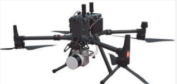
株式会社光響(代表取締役 住村和彦、本社 京都府京都市)は、Hesai製LiDAR(XT-32)、 マッピングカメラ等で構成されるGreenValley International社製「UAV LiDARシステム (型番
続きを読む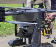
日本語で読みたい方は、 google chromeで開いて、 画面上で右クリックをして 「日本語に翻訳」をクリックしてください Yellowscan LiDAR has been tested and certified
続きを読む